
What Every Marine Consultancy Project Involving Recreational Boating Is Missing
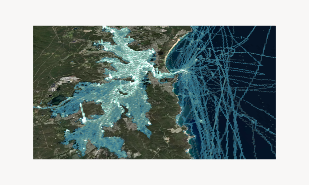
Marine consultants and coastal engineers shape decisions that can allocate hundreds of millions of dollars in coastal infrastructure, environmental approvals, and waterway strategy. In many of these projects, the recreational fleet is a key driver of demand and a significant contributor to environmental and social impact, and is typically characterised through registration data, intercept surveys, stakeholder consultation, and historical literature. These methods are valuable and remain essential, but they produce a partial picture. Rarely can they reveal where recreational boats go, when, or how often. DECKEE provides the behavioural evidence layer the existing stack is missing, already used by government waterway agencies across Australia and the United States, and now available to support consultancy projects directly.
The recreational fleet is a factor in most projects, and is often the hardest part to measure
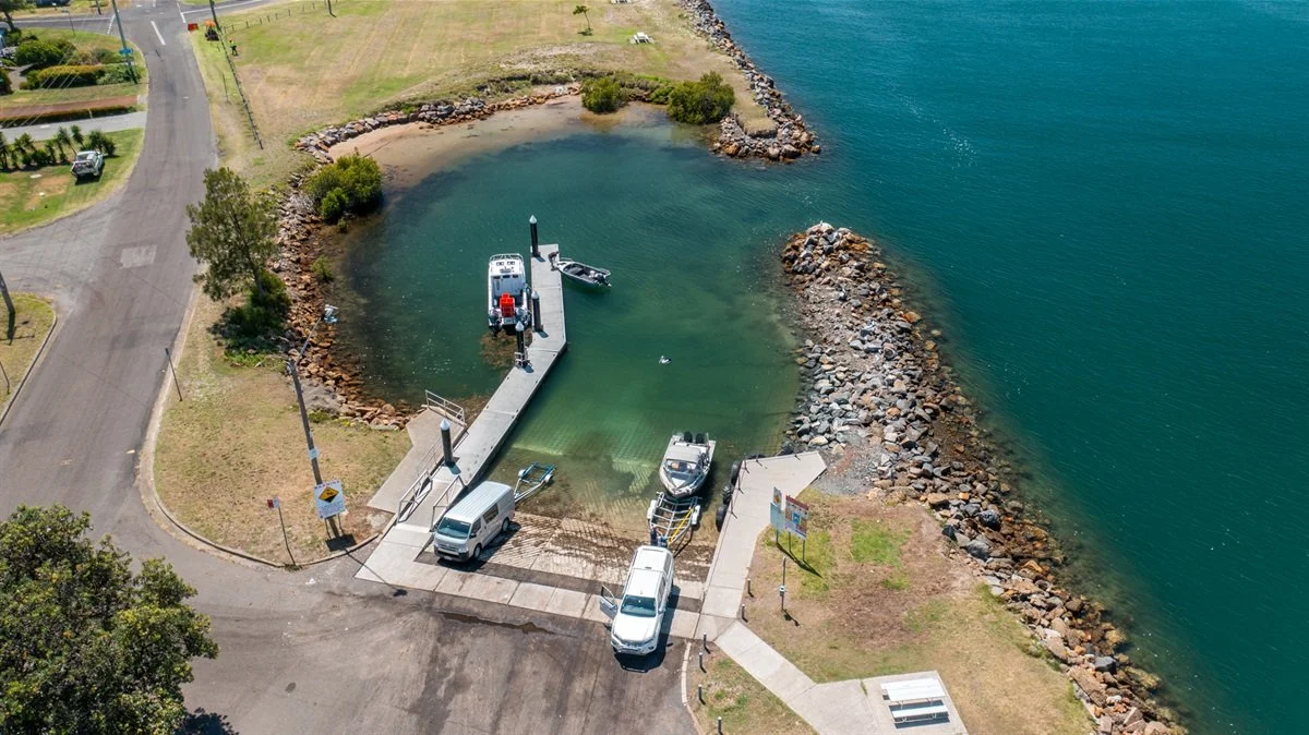
A recurring pattern shows up across marine consultancy projects where recreational boating is part of the puzzle. A coastal engineering firm scopes a new boat ramp, breakwater, or marina expansion. A planning consultancy prepares an environmental impact statement for a port redevelopment, marine park, or offshore wind lease. A transport advisory firm builds a 10-year demand forecast for state boating infrastructure investment. In each of these scenarios, the recreational fleet is part of the analysis. Recreational vessels are the users of the new infrastructure, an existing user group whose access and activity may be affected by the EIA, and the demand drivers in the forecast.
The recreational use sections of these reports rely on a combination of methods that has been the industry standard for decades.
What the established methodology stack tells you
A consultant's recreational use methodology typically draws on a broad set of sources: vessel registration, marina and berth occupancy data, local government permit and mooring records, intercept and ramp surveys, stakeholder consultation, aerial and drone observation, AIS for the small fraction of recreational vessels that transmit, tourism and visitation statistics, industry reports, and academic literature. Several of these are well established. Some are emerging, including generic mobility data from telco, satellite, or fitness platforms.
On-water behaviour is commonly characterised through four sources. Each has its strengths, but none capture behaviour at the granularity, or with the recency, that most projects would benefit from.
Registration data tells you how many vessels are registered in a given area, and typically includes attributes like vessel type, length, and the postcode of the registered owner. It is the single most common input in demand modelling and it is genuinely useful for catchment analysis. Accessing it is rarely straightforward. Agencies hold registration data in different formats across jurisdictions, currency varies, and getting a current extract for a specific project area often requires formal data requests that take weeks or months. Even when access is sorted, registration data does not tell you whether those boats are launched once a year or every weekend, where they go, or how far they travel.
Intercept and ramp surveys produce rich qualitative information about operators, vessel types, trip purpose, and self-reported destinations. They are expensive, time-bounded, and capture a small set of locations on specific days. Generalising a survey weekend to a year of behaviour is methodologically risky and well understood to be so by the firms who run them.
Stakeholder consultation with clubs, marinas, industry association chapters, tourism operators, and local government is essential for understanding the human and political context of a project. It is also subject to recall bias and the natural tendency of vocal stakeholders to over-represent their own use patterns. Consultation captures what people report doing, which can differ from what the broader fleet is doing.
Historical reference data is the only published source of behavioural inputs on a specific waterway in some cases. The Queensland Recreational Boating Facilities Demand Forecasting Study, prepared by BMT for Maritime Safety Queensland and published in 2023, is a good example of how this works in practice. It is the current reference for ramp capacity and prioritisation across Queensland and is intended to support infrastructure planning out to 2041. The methodology is sophisticated, combining statistical modelling, vessel registration data, Census-derived ownership trends, and inter-LGA movement inferred from mobile device location data. But by the nature of the consulting cycle, the data underlying it was collected up to 2022. The previous edition was published in 2017, the one before that in 2011. Infrastructure decisions have to be made at a point in time, but the reference they are based on can be years old by then, with no way to check it or measure it against current behaviour.
Generic mobility data from telco, satellite, or fitness platforms has started appearing in marine consultancy work as well. These platforms are built for general-purpose movement analysis, not waterway analysis. They do not distinguish a boat from a car ferry passenger or a coastal walker, do not understand ramps, channels, anchorages, or hazards as objects in the data model, and do not contextualise activity against vessel type, trip purpose, or boating conditions. The data exists, but the marine signal that comes out of it is weak compared to a platform purpose-built for boating activity.
Used together, these sources are how the industry has characterised recreational use for the better part of three decades. The wider methodology stack has evolved over that time, with GIS, drone observation, AIS integration for commercial overlap, and increasingly sophisticated demand modelling all playing a part. What's still missing is a behavioural layer: a continuous record of how the recreational fleet uses the water, observed at scale rather than inferred.

Where the gap shows up in projects
The gap shows up across many project types. In infrastructure design and prioritisation, government programmes like Queensland's Marine Infrastructure Investment Program commit hundreds of millions per cycle against demand forecasting studies that refresh every five to seven years, with decisions made between editions against snapshots that may no longer reflect current conditions. In environmental and planning advisory, recreational use baselines for marina developments, port expansions, marine park reviews, offshore wind leases, dredging programmes, and aquaculture leases go through proponent review, regulator review, and public exhibition, and have to hold up under all three. In strategy, masterplans, and demand forecasting, defensible projections forward depend on a current picture of where the fleet concentrates and how that concentration is shifting.
In each, the consultancy is producing the deliverable the client commissioned with the data that has historically been available. The opportunity now is to add a layer that was not previously available.
What behavioural data lets a consultant answer
A behavioural recreational dataset of the kind DECKEE produces answers a different set of questions to the methodology stack already in use, and the answers feed directly into the analytical sections of consultancy deliverables:
Where does recreational activity concentrate within a study area, and how does that concentration shift seasonally, around weather, and around events?
Which boat ramps and access points are over-utilised relative to their catchment, and which are under-utilised?
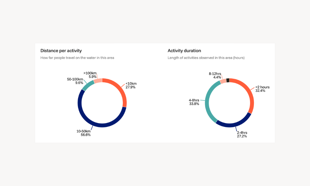
How far do boats from a given launch point travel, and where do they stop, fish, anchor, or transit?
How does activity respond to new infrastructure, navigational changes, hazard notices, or campaign messaging?
What is the year-over-year trend in recreational use of a specific waterway, ramp, channel, or proposed development site?
For two candidate sites for a new facility or restriction, which has the higher pre-existing recreational footprint, and what does the surrounding usage pattern look like?
Defensibility for formal deliverables
Each engagement with DECKEE comes with a documented methodology, the underlying sample size, and a description of how activity figures are produced. DECKEE's contextual boating data can also be fused with third-party location datasets, which extends the behavioural layer across a much broader sample of on-water activity than any single source alone. (We've made a related argument about contextual data for commercial vessels in an earlier piece on AIS.) The outputs are designed to feed into the consultant's existing analysis. Where DECKEE data agrees with the consultant's other sources, it builds confidence in the overall picture. Where it disagrees, the gap is informative and points to where to look next.
The data is already used in formal government decision-making. The DECKEE Operations Platform is used by Safe Transport Victoria, Marine and Safety Tasmania, Marine Safety South Australia, and the Florida Fish and Wildlife Conservation Commission, alongside other government partners across Australia and the United States. The same data that supports ministerial briefings and operational decisions for those agencies is available to support consultancy work for projects in the same jurisdictions.
How DECKEE supports consultancy projects
DECKEE works with consultancies on a project-scoped basis. The primary deliverables are tailored reports and dashboards covering the specific Areas of Interest relevant to the project, available as a point-in-time view or as ongoing measurement over time, with the sample context and analytical detail required for inclusion in the consultant's broader advisory. Engagements can be scoped to work within the project budget.
Working on a project where recreational boating is part of the picture? Contact us for a demonstration today.
DECKEE is a maritime safety and decision intelligence platform serving recreational boaters and government waterway agencies. Learn more at deckee.com/data.