
Recreational vs Commercial Vessel Tracking: Why AIS Sees Less Than 5% of Boats
TL;DR: AIS (Automatic Identification System) was designed for commercial shipping, and it does that job well. By international and US law, only large commercial vessels, passenger ships, and most fishing vessels must carry it. Recreational boats, which make up over 90% of vessels on most populated waterways, are not required to transmit AIS and overwhelmingly do not. This leaves waterway agencies with strong visibility of the commercial fleet and weak visibility of the recreational fleet they actually spend most of their resources managing. Closing that gap does not require replacing AIS or any other existing tool. It requires adding a recreational activity layer that integrates with AIS, ramp counters, cameras, surveys, and registration data to give agencies a complete picture.
What AIS is, and what it is not
AIS is a VHF-based transponder system standardised by the International Telecommunication Union and adopted by the International Maritime Organization under SOLAS Chapter V. Its primary purpose is collision avoidance and traffic management for large vessels. Each transponder broadcasts ship identity, position, course, speed, and navigational status to other AIS-equipped vessels, shore stations, and satellites.
Carriage is mandatory for a narrow set of vessels. Under SOLAS, AIS is required on:
All ships of 300 gross tonnage and above on international voyages
Cargo ships of 500 gross tonnage and above not engaged on international voyages
All passenger ships, regardless of size
In the United States, the Coast Guard extends this to commercial vessels of 65 feet or more, certain towing vessels over 26 feet and 600 horsepower, vessels carrying more than 150 passengers, and vessels engaged in dredging or moving certain dangerous cargo. The European Union requires AIS on fishing vessels over 15 metres in length under Directive 2002/59/EC, which was fully phased in during 2014.
What none of these regimes require is AIS on recreational vessels. A privately operated motorboat, jet ski, tender, sailing dinghy, kayak, or trailerable runabout has no legal obligation to transmit. Most do not.
What about recreational boats that do carry Class B AIS?
Class B AIS units exist for the recreational market and a minority of recreational boaters use them. Adoption is concentrated among offshore cruising yachts, larger sailing vessels, and operators who routinely cross commercial shipping lanes. They install Class B for their own safety and visibility to commercial traffic, not for any regulatory reason.
There is no comprehensive global figure for Class B penetration in the recreational fleet, but every available regional indicator points to a small single-digit percentage. The fleet that matters most to a typical state or city level government agency – small pleasurecraft, trailerboats, runabouts, jet skis, and paddlecraft – is effectively absent from AIS feeds. And the recreational vessels that do carry Class B are a self-selecting subset of the fleet: larger, offshore-oriented, and skewed toward operators who already prioritise safety equipment. Drawing fleet-wide conclusions from that sample can misrepresent the recreational population most agencies actually manage.
So the picture is more nuanced than "AIS sees zero recreational boats." AIS sees a thin, biased slice of the recreational fleet, and even for that slice it provides commercial-style transponder data rather than the behavioural context an agency needs.
The boating activity that AIS cannot see
Around 400,000 AIS devices broadcast vessel locations globally each year. The total of actively transmitting AIS units sits somewhere between roughly 500,000 and 1 million worldwide, depending on whether the count includes Class B voluntary installs, fishing vessels, and aids-to-navigation. The world's mandated commercial fleet of vessels at 100 gross tonnes and above is around 105,000 ships.
Now compare that to the recreational fleet. Global recreational boat estimates sit around 30 million vessels. In the United States alone there are approximately 11.8 million state-registered recreational boats, with another 3.6 million unregistered kayaks, canoes, and small craft. Florida leads with 1.2 million registered recreational boats. Australia, the UK, France, Italy, and Germany each have hundreds of thousands to over a million registered recreational vessels. Over 6 million recreational boats are kept in European waters. In the Mediterranean, recreational craft between 2.5 and 24 metres represent more than 90% of the total fleet of vessels.
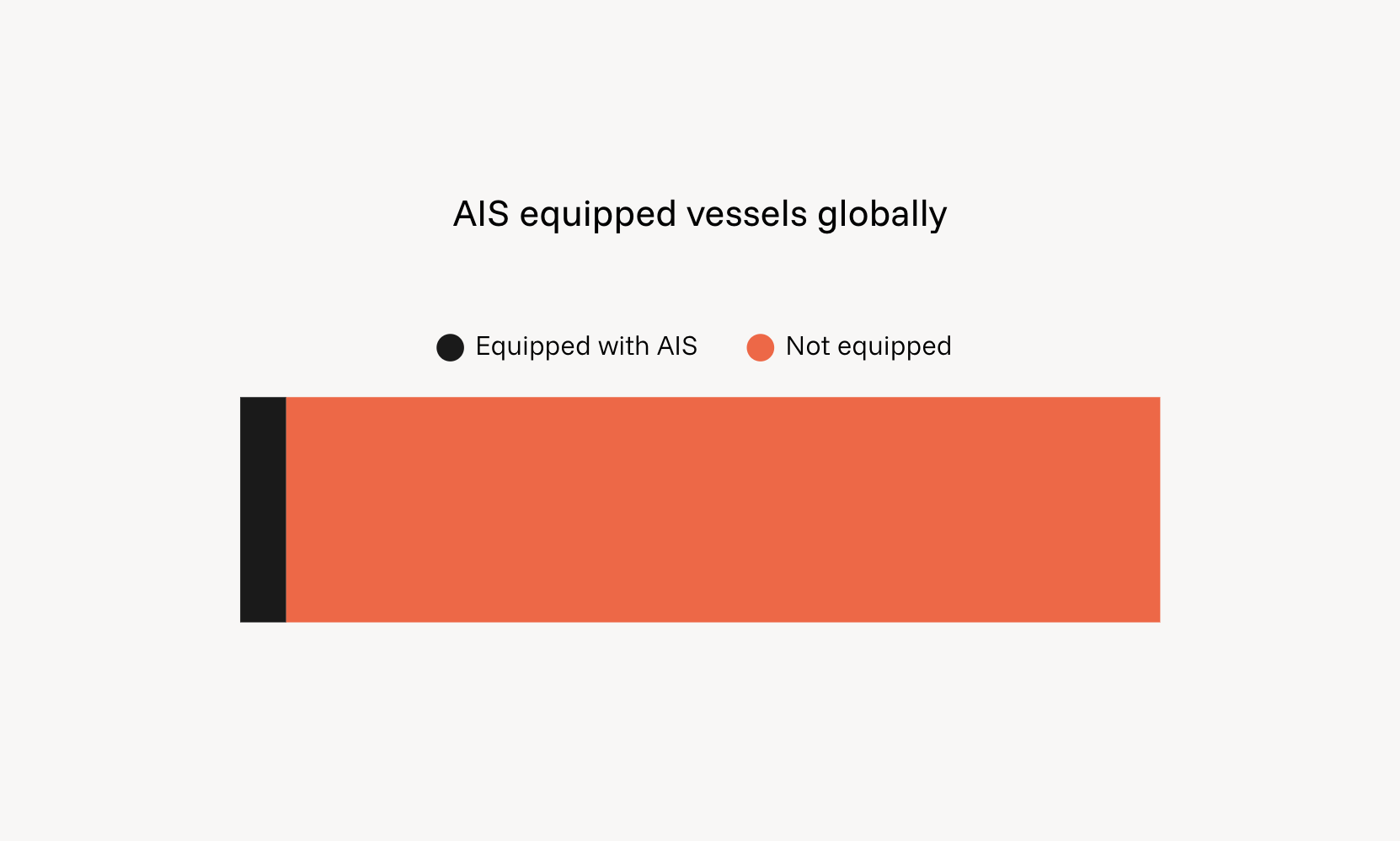
Even at the high end of 1 million AIS-equipped vessels globally, more than 95% of the world's recreational craft do not transmit AIS. In any populated coastal or inland waterway in the developed world, recreational vessels outnumber AIS-transmitting vessels by orders of magnitude.
When an agency relies primarily on AIS to understand activity on its waterway, it is observing the smallest, most regulated slice of the fleet. The vast majority of boats that drive most of the agency's actual workload, including search and rescue, incident response, infrastructure planning, education campaigns, and enforcement, are largely invisible.
AIS is doing exactly what it was designed to do. Using it as a proxy for total waterway activity is the issue.
Why this matters for waterway agencies
Most state maritime agencies are tasked with managing recreational waterways. Their KPIs are typically tied to recreational outcomes: fatality rates, incident response times, infrastructure utilisation, education and compliance. AIS feeds and AIS-derived analytics platforms cannot serve as a primary visibility tool for this work, because the recreational fleet that drives those KPIs is largely absent from the data.
The practical consequences are felt across planning, risk awareness, and communications, among others:
Planning decisions get made on incomplete data. Where should a new boat ramp go? Which channel needs better signage? Which areas justify increased patrol presence on a long weekend? AIS will not answer these questions because the boats that use ramps, signs, and patrol zones are not on AIS.
Risk awareness lags reality. Recreational hotspots shift seasonally, with weather, around holiday periods, and in response to new infrastructure or events. Without a recreational activity signal, agencies often only discover an emerging high-use area after an incident draws attention to it. AIS provides no early warning here, because the boats driving the activity are not transmitting.
Communications campaigns hit the wrong audience or fail to land. Safe boating campaigns, hazard notices, and seasonal reminders need to reach the people actually on the water. Without recreational activity data, agencies fall back on registration databases and general media buys, neither of which can target or measure behavior change.

What about ramp counters, surveys, cameras, and patrol logs?
Most agencies already use a mix of these.
Ramp counters and traffic counters give a reliable count at a fixed point. They cannot tell you where the boat went after launch, how far it travelled, what hazards it encountered, or how long it stayed out. Coverage is limited to the ramps that are instrumented.
On-water surveys produce rich qualitative data, including operator behaviour, equipment, and trip purpose. They are expensive, infrequent, and capture a moment in time. Generalising from a survey weekend to a full year is methodologically risky.
Fixed cameras and drone observation are powerful at known sites, especially when paired with machine learning detection. They are expensive to deploy and run, and do not scale economically across a full jurisdiction.
Patrol logs capture incidents and on-water enforcement contacts, both of which are important. By definition they are not a sample of the underlying activity, only of the parts of activity the patrol encountered.
Registration data tells you who owns boats. It does not tell you who is using them, when, or where.
None of these are wrong. They are partial views, which is exactly why agencies use several at once. Adding recreational activity data to this mix does not replace any of them. It acts as the connective layer that lets the others be interpreted in context.
What recreational vessel tracking actually requires
Recreational boaters will not start carrying transponders. Voluntary AIS adoption among recreational users has been slow for two decades and shows no sign of accelerating. The data has to come from somewhere else.
A model that works is consent-based mobile activity data. Boaters already use smartphones for navigation, weather, marine forecasts, ramp information, and tide times. When recreational boaters use connected apps for these functions, those apps produce the activity data the agency needs, with the user's knowledge and consent.
This data has a different shape compared to AIS. It is anonymized at the agency view, aggregated to areas of interest rather than individual vessels, and built around behavior patterns rather than continuous track logs. It answers questions AIS cannot:
How many recreational vessels were active in this bay last Saturday compared to the average Saturday?
Which ramps had the highest activity during the long weekend?
Where are recreational boaters concentrating around bridges, hazards, or new infrastructure?
How did activity respond to a Notice to Mariners, a weather event, or a campaign?
Limitations of app-based activity data, and how to address them
App-based data has the same property as every other recreational tracking method: it is partial. The honest limitations are worth naming directly, because the way agencies handle them determines whether the data is useful or misleading.
Selection bias: App users are not a perfect mirror of the full recreational fleet. They tend to be more digitally engaged, often more safety-conscious, and may over-represent certain segments. A simple "active users on the water" figure read in isolation will not always match a true population census.
Sample size variance: Penetration is not uniform. A region with high app adoption produces high-confidence reports. A region with low adoption produces directional signal but should not be treated as authoritative on its own.
Data is activity, not a vessel census: App data tells you about behaviour. It does not give you a one-to-one count of every vessel on the water.
The right response to these limitations does not involve ignoring them or overselling the data. It involves using the data as one layer among several, and integrating it with sources that have complementary strengths. DECKEE addresses this in three ways:
Triangulation with agency-owned data. Reports include sample size context and are designed to be cross-referenced with registration data, ramp counters, patrol logs, and survey results. Where DECKEE data agrees with these sources it builds confidence. Where it disagrees the gap itself is informative and points to where to look next.
Integration of third-party location and activity data. Where representativeness needs to be improved for a specific jurisdiction or report, DECKEE can integrate complementary third-party datasets to bolster coverage. The platform is built as a data integrator, not a single-source provider.
Transparent methodology. Reports include the underlying sample size, the comparison baseline, and the methodology used to generate the activity figures. Agencies can see what the data is and is not telling them.
When AIS is the right tool
It is worth being explicit about where AIS is the correct primary source.
AIS is the right tool for:
Commercial vessel traffic management in ports, harbours, and shipping channels
Collision risk assessment between large vessels
Compliance monitoring of mandatory carriage vessels
Search and rescue coordination involving SOLAS-class vessels
Port state control and customs operations
In any of these scenarios, AIS is the authoritative source. Recreational activity data is for managing the recreational fleet. AIS is for managing the commercial fleet. Both are needed in jurisdictions that have both.
How DECKEE closes the recreational gap
DECKEE is the recreational counterpart to AIS-based commercial tracking. The DECKEE mobile app is used by boaters worldwide for safety, exploration, and activity planning. The DECKEE Operations Platform (DOP) gives waterway agencies aggregated, consent-based visibility into recreational activity across their jurisdiction, designed to integrate with the data agencies already collect. Agencies use DOP across a range of work, including:
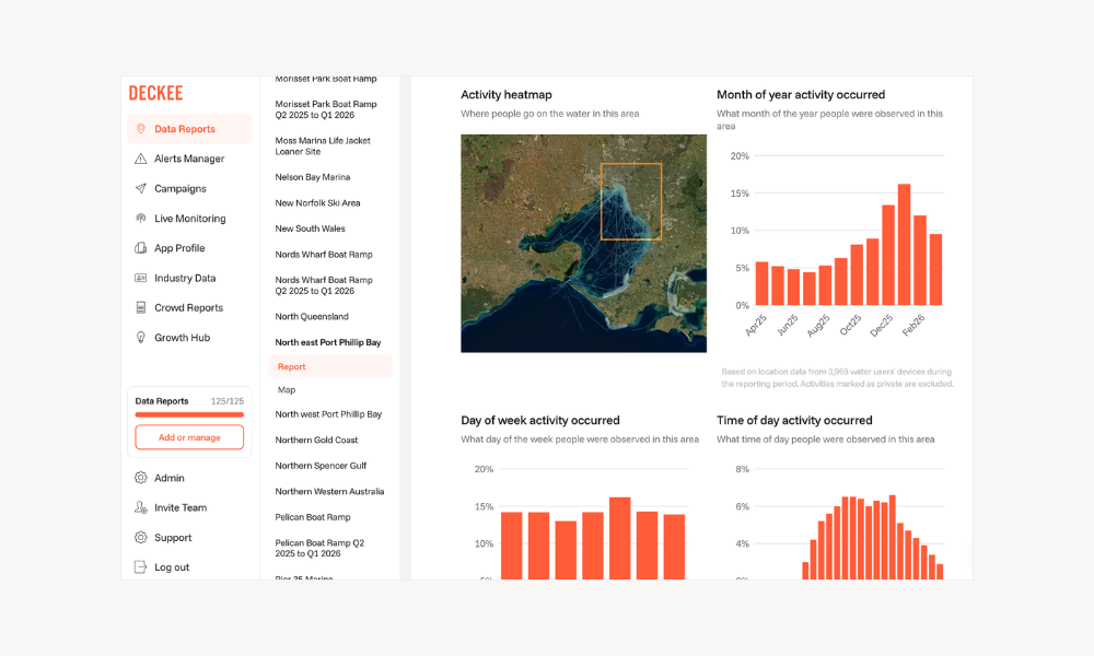
Boating Behavior Reporting: Agencies define areas that matter to them – ramps, channels, hazard zones, infrastructure projects, jurisdictional boundaries – and DECKEE reveals recreational activity volume, patterns, and trends in those areas. Reports include sample size context, geospatial heatmaps, and summaries that are ready for ministerial briefings or executive reporting. Agencies cross-reference these against their own ramp counters, surveys, and patrol data.
Campaign delivery and analytics: Agencies push targeted notices to boaters in specific areas, then measure reach, engagement, and behavioural response. The Florida Fish and Wildlife Conservation Commission uses this for Safe Boating Week and ongoing public safety messaging. Several Australian state and territory agencies use it for seasonal hazard communications and infrastructure-specific notices.
Decision intelligence over time: Activity data accumulates into a baseline. Agencies can detect shifts, validate the impact of interventions, and brief committees with evidence rather than anecdote.
The DECKEE Operations Platform is currently used by waterway agencies including Safe Transport Victoria, Marine and Safety Tasmania (MAST), Marine Safety South Australia, and the Florida Fish and Wildlife Conservation Commission, alongside agencies in other Australian states.
AIS and DECKEE are complementary. AIS handles commercial vessel tracking. DECKEE handles recreational activity intelligence. An agency running both, alongside its existing ramp counters, cameras, and patrol logs, can achieve visibility across the full fleet on its waterways.
The takeaway
AIS is excellent at what it was built for. Globally, fewer than 1 million vessels actively transmit AIS, against an estimated 30 million recreational craft, meaning AIS provides visibility of less than 5% of the world's vessel population. The recreational fleet that AIS does not see drives most of the workload of a waterway agency. Seeing the other 90%+ requires a different data layer, built on the platforms recreational boaters already use, with consent and aggregation at its core, integrated with the other tools agencies already operate.
Waterway agencies that want to plan from evidence, target their communications and infrastructure investment effectively, and brief their stakeholders with confidence need recreational activity data alongside their AIS feed and existing methods. That is what DECKEE is built to provide.
Want to see what this looks like for your jurisdiction? Request a sample Area of Interest report covering a section of your waterway and we will walk you through the methodology, the data, and how it fits with what you already collect.
DECKEE is a maritime safety and decision intelligence platform serving recreational boaters and government waterway agencies. Learn more at deckee.com/data.