
MARINE WEATHER FORECAST: DECKEE'S GUIDE FOR BOATERS

If you’re planning to go boating regularly, it’s time to learn how to read marine forecasts. The weather has a huge impact on the sea. Certain conditions can put you and your vessel in danger.
Our step-by-step guide to marine weather helps beginner boaters understand and interpret forecasts. Learning this skill will allow you to make an informed decision on whether to go boating or not.
MARINE FORECAST: HOW DOES IT DIFFER FROM A REGULAR ONE?
On land, we notice the weather in our day-to-day life. We prepare for a cold front, get our umbrella out for a heavy rain shower and follow extreme weather warnings. However, while the weather may influence our choice of outfit and mood, it usually doesn’t have a big impact on our routine. Unless there is an unusual weather event, such as a cyclone/hurricane, flooding or heavy snowfall, we don’t have to pay much attention to the weather.
On the sea, you depend on the weather. The ocean is heavily affected by the wind, currents and tides. Being on a boat means that you are exposed to all weather conditions. On some vessels, you are literally out there in the elements. This is why you can’t go boating without checking the marine forecast. The weather dictates your plans.
THE KEY ELEMENTS OF MARINE FORECASTS
In order to read a boating forecast, it’s important to understand the key elements included in one and why they are important for boaters.
Wind
Wind conditions are extremely important, whether you are on a sailboat, engineless boat or motorboat. The strength of the wind affects the waves and can risk damage to your rig and sails. Moreover, the direction of the wind can slow your progress down, if you are sailing against the wind and waves on a boat with little or no engine power.
Finally, knowing the direction and force of the wind will allow you to make a decision on where to anchor. You should look for a place with as much land protection as possible.
Wind strength is measured in knots. One knot is roughly 1.15 miles per hour, or 1.85 kilometres per hour. To indicate what direction the wind blows from, meteorologists use the cardinal points. A SSW wind will be a wind out of the south, south west.
The Beaufort scale combines wind conditions with the typical wave activity they generate. The scale goes from force 0 to 12 - from calm wind and a mirror-like sea, to hurricane force winds and monstrous waves.

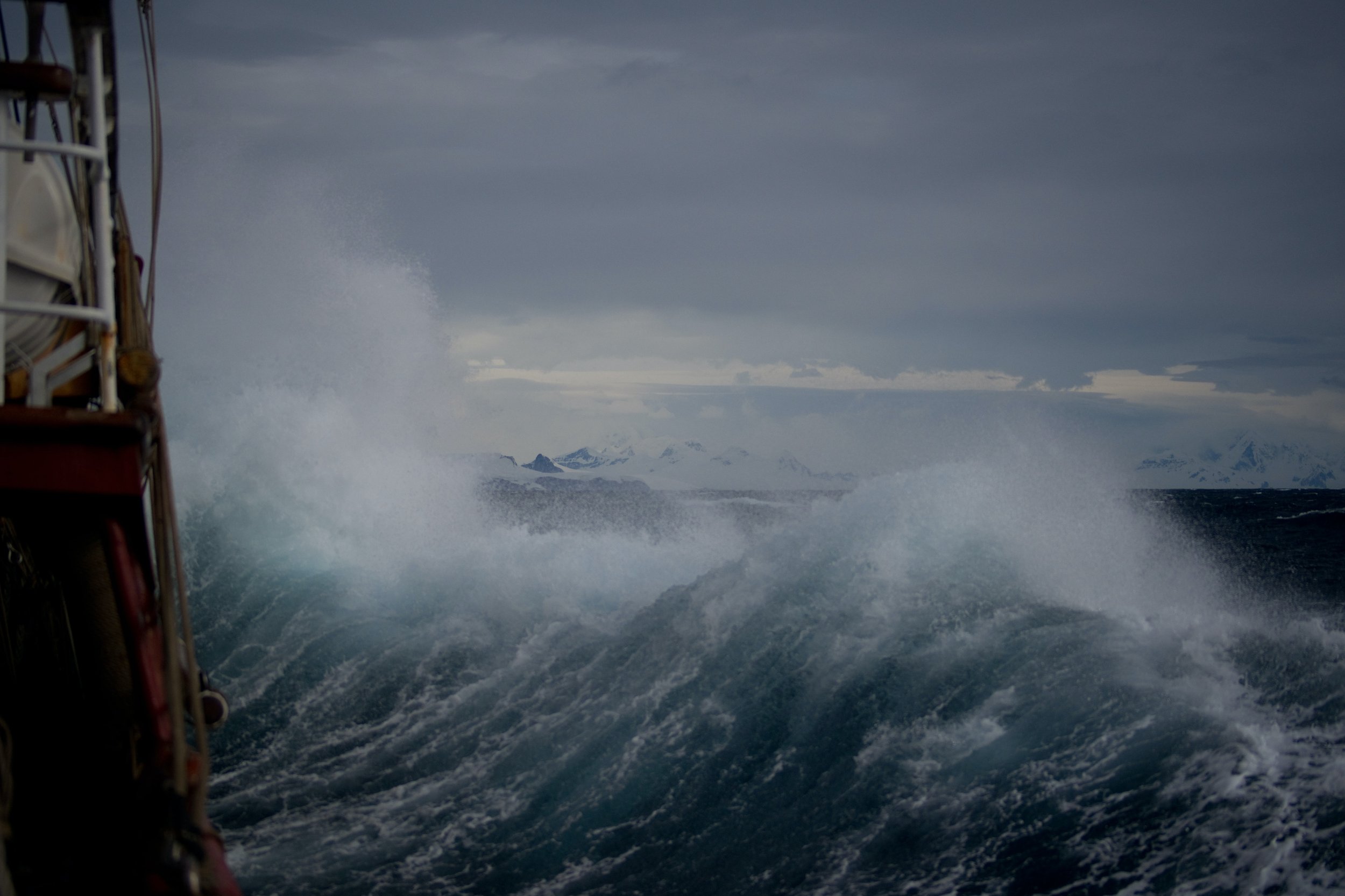
Swell and wave height
Swell is a series of waves that move beyond the area where they were generated. The distance between the crests (tops) of the waves make up the swell. This distance is much longer for swell waves than for wind-waves - waves generated by the wind, moving over the ocean.
The metrics you’ll want to check in this instance are wind-wave height and direction, plus swell height, direction and period. The heights are calculated in meters or feet; the period in seconds. The direction is indicated by the cardinal points. Bear in mind that the wind-waves and the swell can hit you from different directions at the same time, making for a confused sea state and an uncomfortable ride.
Sun or rain
Depending on what type of watercraft you are going out on, sun and rain may affect you. On open boats, jet skis and dinghies, you’ll probably want to wait for a dry spell. On a big motorboat or sailboat with weather protection, some rain showers won’t affect you as much.
Also check the forecasts for any thunderstorms. A lightning strike can cause major damage to a boat and fry all the electronics on board.
Currents
A current is a continuous, directed movement of sea water. Currents are generated by a number of forces, such as the wind, waves, salinity differences and more. You don’t have to understand all the complicated science behind them, but you do need to know what’s going on on the surface.
All you need to do is check if there is a current in the area you’re boating in. If there is one, look at its strength and direction. The speed is measured in knots and the direction is indicated by the cardinal points, but unlike the wind, the direction is shown in the direction it is heading towards, not the direction it is flowing from. A three-knot, west-flowing current is travelling at 5.5 kilometres per hour, or 3.4 miles per hour, moving from east to west.
Why check the local currents? The force of a current can be very strong, so sailing against one can make progress difficult. They can also affect the sea state if, for example, the current is flowing against the wind, which makes the sea surface much rougher.

Tides
Tides are the rise and fall of sea levels, caused by the gravitational forces exercised by the Moon and Sun, together with the rotation of the Earth. While understanding how tides work is useful, in order to go boating, you just need to check the tide times.
Most places in the world will be affected by tides, as the water gets deeper or shallower by a few meters four times a day. How does this affect boaters? When choosing where to anchor, you will need to make sure you have enough water under your keel at low tide.
Straits, channels, estuaries, lagoons and rivers are heavily affected by tides. The water will travel faster in these places when the tide changes, so the tide times will be a good indication of when it’s best to approach or leave.
Finally, in some instances, when the tide is large enough to generate a strong current, this can lead to a rough sea state, if that current opposes the wind. You can check tide information on the Deckee app.
Fog and visibility
Having good visibility on the ocean is crucial. The person at the helm (or on watch) needs to make sure that you’re not on a collision course with another boat at all times. Being on a boat, on the sea, means your visibility range is rather small, so you need to look around often. For this reason, reduced visibility and fog can be dangerous at sea.
Let’s see how visibility is measured. Fog is a visibility of less than 1 kilometre. Mist is visibility between 1 kilometre and 2 kilometre. Haze is visibility from 2km to 5km.
That’s it. These are all the metrics you need to look up before going out boating. Some weather apps don’t include all this information, so you’ll need to check multiple sources.
COASTAL MARINE FORECAST VS OFFSHORE MARINE FORECAST
There are two kinds of marine forecasts you can look at: coastal and offshore. The coastal (sometimes called inshore) forecast is usually accurate and will show the weather for the local coast and a few miles off it. This type of weather is forecasted using weather stations on or near land, which are easy to get to and service.
Offshore marine forecasts, on the other hand, predict the weather far from the coast, even in the middle of an ocean. The metrics are measured by buoys located in the middle of the sea. For this reason, offshore weather can be slightly less reliable and detailed than the coastal one.
WHERE TO LOOK UP YOUR LOCAL MARINE FORECAST
There are a number of free apps and websites you can check for your local marine forecast. PredictWind and Windy are two of the most popular. In Australia, The Bureau of Meteorology is the go-to, while Willy Weather is used by many.
MagicSeaweed is the website usually chosen by surfers. And of course, you’ll be able to check detailed marine weather directly on the Deckee app, while you plan your day out on the water. On the app you will also find charts and safety information.
PASSAGE PLANNING
Make sure to check the weather for the whole period of time you are planning to be sailing for, and for a little later. You may be delayed and, if you are, you need to know what to expect.
As you grow in confidence and start planning multi-day trips, you will need to make a passage plan. This means drawing your route and planning your departure and arrival times, relying on the marine forecast.
For example, if you are on a sailboat, you will need to plot your course based on the wind, swell direction, currents, and tides. Your objective is to make sure you can successfully make progress at all times and arrive into port in favourable conditions.
MARINE FORECAST FAQ
How many knots is too windy for boating?
A wind speed over 20 knots is typically too much for a beginner boater. Experienced skippers can handle up to 50-60 knots of wind, though few would enjoy it.
What is good weather for boating?
Ideally, a sunny, haze-free day with a light or moderate breeze and no currents.
What is bad weather for boating?
A day with reduced visibility, strong wind, thunderstorms or a strong current flowing opposite to the tide.
What does “mixed swell” mean?
A “mixed swell” is what sailors call a crossed swell. It happens when two swells affect a specific area at the same time. The swells can also have a different wave height and period. We hope you found this guide to marine forecasts useful. Stay safe out there!
Weather safety is important. Wherever you are, don’t venture out to sea without checking the forecast. Only go boating in conditions you are confident you can handle.
Download the Deckee app from the App Store or Google Play for free to stay safe on the water. Check the detailed marine weather forecast, track your boat trips, inspect Aids to Navigation, and more. Join our community of passionate boaters to find and share your favourite anchorages, marinas, or fishing spots.