
AIDS TO NAVIGATION: THE ESSENTIAL GUIDE

The world's waterways have Aids to Navigation that guide boaters via a network of signs, symbols, buoys and markers.
Knowing these simple Aids to Navigation (ATONs) will help you stay safe on the water, as it tells a boat operator how to behave and interact with other boats. These markers typically signify isolated dangers, indicate the route to be followed and provide a path for precise plotting.
Be it visible, audible or electronic symbols, the system is designed to make navigation as clear and safe as possible, especially in congested areas or hazardous waters.
The Deckee app's map features many thousands of interactive ATONs to help guide boaters to safe waters and provide information about different nautical aids.

COMMON ATONS YOU WILL ENCOUNTER
Lateral markers
Lateral markers indicate the edges of safe water areas. For example, they show a channel as you enter a harbour from the open sea.
Navigational safety is ensured worldwide by IALA - the International Association of Marine Aids To Navigation and Lighthouse Authorities. IALA divided the buoyage system into two areas: Region A and Region B.
Region A includes:
Europe
Australia and New Zealand
Africa
most of Asia
India
Region B includes:
North, South, and Central America
Japan
Korea
the Philippines.
So the same ATONs will have a different meaning, depending on which area you are in. Only lateral markers differ between the two regions, though.

Picture credit: NauticEd
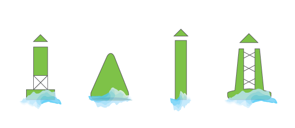
Red lateral marker
These markers are coloured red. In IALA Region A, they indicate the port side. In IALA Region B, they show the starboard side. In Region A, they are odd-numbered, while in Region B they are even-numbered.
Keep them on your left or right side (depending on where you are) when travelling from open waters towards the shore.
As you can see from the image above, the shapes of lateral markers differ slightly in the two regions, but you will easily recognise them on the water.

Green lateral marker
These markers are coloured green. They indicate the starboard side in IALA Region A and the port side in IALA Region B. In Region A, they are even-numbered, while in Region B they are odd-numbered.
Keep them on your right or left side (depending on where you are) when travelling from open waters towards the shore.
IntraCoastal Waterway markers
Markers along the Intracoastal Waterway work a bit differently. They run clockwise around the coast and are uniquely marked with a yellow reflective symbol.
Yellow triangles should be passed keeping them on your starboard, while yellow squares should be kept to port.
Dayboards
Diamond-shaped dayboard markers help boaters determine their location. They can come in white with red, green, or black diamonds and are lettered so they can be matched to a nautical chart to check position.

Danger Markers
These markers indicate an isolated danger with navigable water around it. Practice caution when you see a marker like this. You can identify a danger marker by its black and red bands with two spherical topmarks above it.
Information markers
To assist boaters by informing them of special restrictions or dangers that they are approaching, there are white markers with orange bands which convey different instructions depending on the type of shape.
An open diamond signifies danger, while a diamond with a cross is an exclusion area. A circle indicates an upcoming operating restriction, such as a speed limit. Meanwhile, a square or rectangular shape typically conveys helpful information.
Lights
Around waterways you may also find lighted aids to assist with navigation. You can use the features of the ATON's light to both identify it and ascertain its purpose. This is measured by the time in seconds needed for one complete cycle of changes.

IMPORTANT POINTS TO REMEMBER
Checking markers
Always have the appropriate nautical charts on board your vessel to cross-reference with the ATONs and the app information. This will help avoid confusion, if you travel from a IALA Region A to a IALA Region B.
The interactive ATONs on the Deckee app can be used by boaters to get further information on the type of marker, its location and its specific purpose.
Navigational awareness
Stick to the main channels indicated on the map, and avoid taking shortcuts even if you are confident you can navigate through them. This just causes confusion for other boaters.
Make sure you are familiar with operating your boat so you can concentrate on interpreting ATONs. If in doubt, slow down.
Avoiding collisions
Boaters who pass too close to a buoy risk collision with a buoy or with submerged materials and the obstruction that the aid marks. Boaters must not rely solely on any single ATON for determining their position, particularly buoys.
Always maintain a safe distance from all ATONs.
Wear a life jacket
The number one cause of boating fatalities is drowning. We recommend that you wear a life jacket at all times while out on the water.
Proper and safe on-water navigation has many facets and the skipper has a number of responsibilities when operating a vessel. ATONs are there to assist with making the correct decisions out on the water by removing that element of doubt. We recommend that you plan ahead for your next trip by looking up your course ahead of time by checking Deckee's interactive ATONs.